
The Chilkoot Trail has had a long and colourful history. It was first used as a trade route between the coastal first nations in Alaska and the other first nation groups in central and southern Yukon. When gold was discovered in the Klondike in 1897, the trail served as a route to get 100 000 fortune-seeking miners over the mountains and on a river system to the Dawson gold fields. Today it is the backpacking trip of choice for many Yukoners. It's popularity has grown, and tourists from around the world come to retrace the miner's steps. Last week, five members of the Yukon ski team, including myself, decided to cover the fifty-seven kilometers of rough trail in one day.
The Chilkoot trail begins in Dyea, Alaska and ends at Log Cabin in Northern British Columbia. The trailhead is one hundred and eighty kilometers from Whitehorse, so people usually stay overnight in Skagway, or camp in Dyea to get an early enough start. We opted to stay in Dyea, as the trailhead is in sight of the campground.
At five o'clock the next morning, bleary-eyed from a short sleep, we shoveled some high energy food into us (nutella on raisin bagels) and headed out. Jeff, Knute, Michael, Lee and myself are all in good shape, but none of us had run for this long or covered this distance before, so an early, six AM start was essential. The trail starts out easy. A few kilometers of it was an old logging road so it is flat, even and fast. After an hour though, it disappears, replaced by a narrow, root, rock and mud covered trail that can trip up just about anyone. We ran through the coastal rainforest for the next two hours following boardwalks partly submerged by beaver-made swamps and meandering with the bends of the Taiya RIver. We were feeling pretty good by the time we reached Sheep Camp, as we had passed many other camps in various stages of alertness: at the first camp, no-one had emerged from their tents. By the second, people were starting to eat breakfast, begrudging our light-weight packs and freedom to run. By the third, people were leaving as we made our first rest stop after three hours of running. from there, the trail climbs. The Chilkoot pass is well over thirty-five hundred feet and you gain most of that elevation in a short time. Along with the elevation gain, the trail climbs out of the rainforest and into the alpine, precipitating massive boulders, a choppy trail and bad weather. After five hours on the trail, we made it up the scales and past the final forty-five degree slope, infamously known as the Golden Stairs. The weather socked in at the summit. As the temperature dropped to less than five degrees and the fog rolled in, we took refuge at the summit cabin to eat, drink and throw on an extra layer.
The pass is about the half way point, and with the major climb completed, and a gently rolling trail in front of us, we felt like we were laughing. Starting just after the summit were large snow patches that made for treacherous footing on sloping, icy terrain. Another hour after the summit and we reached Happy Camp (co-incidentally, the weather cleared, the sun came out and the temperature rose) and stopped for lunch. We probably stopped longer than we should have for lunch as we chatted with hikers who had just rolled out of bed at noon. When we finally got going again, we promptly split our group in two, with Lee and myself taking a high trail as the rest of the group took what looked like a well used trail closer to the lake. It turned out that the lower trail was out of use, and ended in a cliff face a nalf-kilometer later. This resulted in a fifteen minute wait as they picked their way back up to the trail where Lee and I were waiting. from there we tried to run as much as possible, but it was getting hard. We got to Lake Lindeman after eight and a half hours, and we all hit the proverbial wall.
By that time, all of our joints were screaming. Our ankles, our knees and even our hips couldn't stand the strain of running, so we were forced to walk. By the time we reached the rail-road tracks, that painful final eight kilometers seemed to stretch on forever. The multiple kilometer-long straight stretches dragged on our legs for the next excruciatingly slow two hours. After eleven and a half hours we made it to Log Cabin, with everyone tired, sore, grumpy and more than a little bit sweaty. However, our trip wasn't quite over, as (for good reasons, including falling asleep at the wheel) we had to wait for my father to run the shuttle back down to Dyea for us.
Unfortunately, he picked up the wrong set of keys when leaving our house, and only discovered he had the wrong ones by the time he was at the vehicle pick up. When we met him at the end of our eleven hour day, he still had to drive another hour and a half down to Dyea and back, this time with the right keys. This long wait was partially voided by the fact that he brought up some very tasty pizzas from Skagway, but the main thing we wanted to do at that point was shower and sleep.
Over the course of this fifty-seven kilometer run, I wore my heart-rate monitor. According to it I was in zone one (60-75% of my maximum heartrate) for over nine hours and I burned over five thousand calories. Needless to say, the next few days were slow and painful ones.
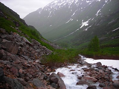
Looking south on the summit climb.
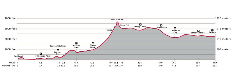
Chilkoot Trail Profile.
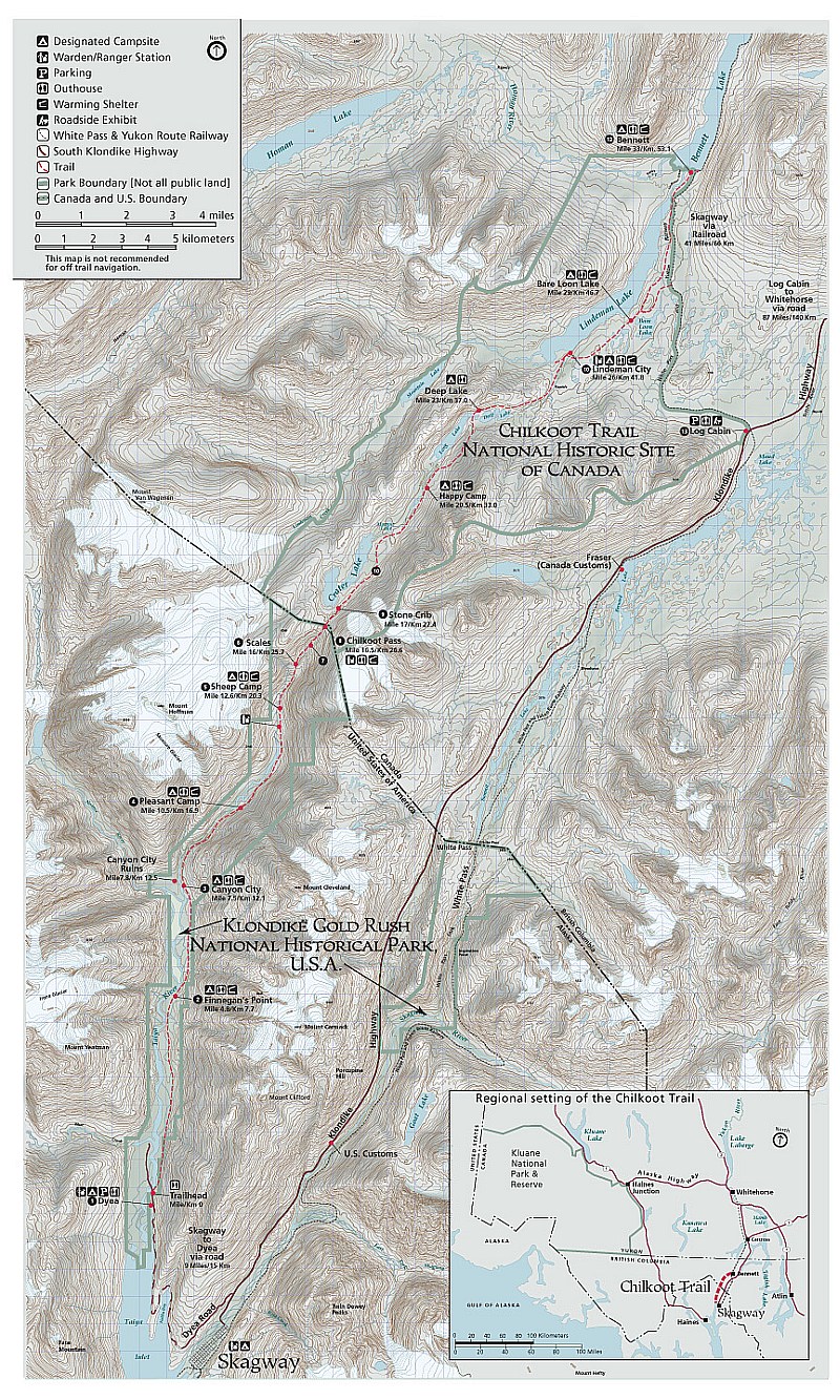
Chilkoot Trail Map.

"Vauhti Waxes. . . the conditions are always right!"