

2008/03/23 - The snow's a little deeper than most year's...
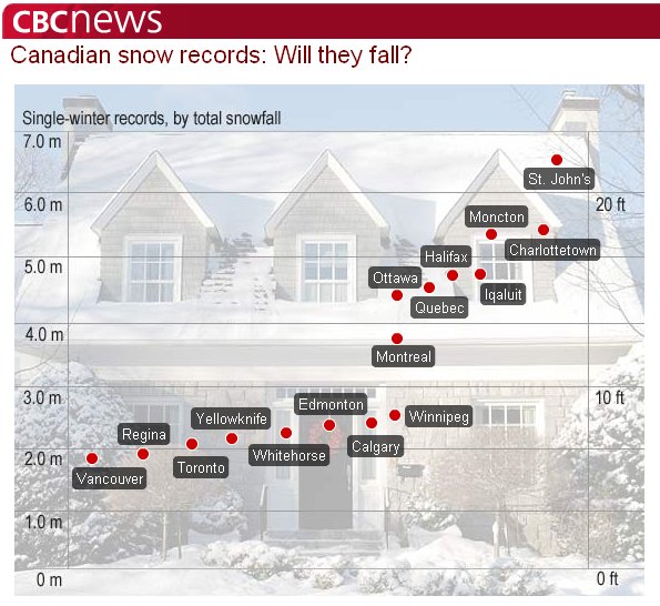
2008/03/13 - A light dusting has the total up to 412cm, 32cm to go. CBC has an interesting article about snowfall records for Canadian cities (click on the image to go to the article)...
2008/03/10 - When the March Madness subsided we had 52cm on the ground, putting us at 410.7cm according to some reports! That's only 34cm shy of the record. Updated plots...


Accumulated snow fall. (This is not snow coverage on the ground, but rather a sum of all the snow that has fallen.)
2008/03/08 - 21cm yesterday as of 1pm today, so that's 376cm and counting! Weathertainment is once again upon us as weather geeks are working hard to entertain people stuck indoors. Checkout this report from the graveyard shift at Environment Canada. Maybe they hired some striking Hollywood writers?
WOCN10 CWUL 070948
Special weather statement issued by Environment Canada Montr�al at
04:48 AM EST Friday 7 March 2008.

.... A jab tonight and the final punch late in the day Saturday ....

Weather synopsis

The winter combat is not over. A great opponent is already in site
but he is smart. In fact, an important southwest flow, along the
mississipi valley, will send a series of depressions toward our
regions in the end of week.

The first one will move up along the Appalachians today. It will move
across the New England tonight while a cold front will move across
southern Qu�bec. These two systems will combine to give a dozen of
centimetres of snow over most of southern and eastern Qu�bec. However
in Eastern Townships, the cold air associated with the front and the
mild air of the low pressure system will clash. Precipitations will
begin as rain but will change in snow overnight over this region but
they could degenerate into freezing rain.

After this first jab to test our defences, a major storm coming from
the gulf of the Mexico will give the fatal blow. This storm will move
up Saturday to the southwest of Qu�bec and will bring us great
amounts of snow. It will be accompanied by strong northeast winds
which will give blowing snow. It seems that all of this will become
mixed with ice pellets like during the last storm. It is still too
early to be more precise over the arrival of this snow because the
track of the low pressure system is still subject to variations.

This is merely an advisory notice and the public is advised to listen
to present and future warnings issued by Environment Canada.
2008/03/06 - Anyone else's shoveling muscles sore yet? If your sore back is telling you we've received well above average snowfalls this winter, you would be correct. As a skier I will never complain about a little shoveling. Besides it's good training, who needs to lift weights when you have heavy wet snow?
We've already accumulated 355cm of snow this winter. While a lot, double what Toronto has received, it is still not close to the 1970/71 record of 444cm. That's also more than the last two winters combined!
Another major storm is expected on Saturday which some are saying could be the biggest of the winter (thus far). If correct we might stand a chance of breaking the all time Ottawa snowfall record. It's not like we have any control over the record, but it's fun to watch. (See Weathertainment.)
Here's the latest Environment Canada Weather Warning for the next storm. (Brett Anderson is forecasting 30-60cm for the area!)
..Snow beginning Friday ahead of next snow storm on Saturday..
The storms keep on coming this winter with the next Major system Threatening to give heavy snow on Saturday.. Especially over eastern Ontario.
A broad area of snow will develop on Friday over the regions ahead of another Texas low estimated to track up the eastern seaboard on Saturday. There is the potential that this storm will intensify into one of the biggest snow makers of the winter for eastern Ontario. Once the track of the low is determined winter storm watches or warnings may be issued.
Listen for further statements. Additional information may also be found by consulting the latest public forecast. The next public forecast will be issued by 5 AM.
Many thanks to Russ Alexander for compiling the plots below from Environment Canada's Climate Data On-line.

Accumulated snow over the years. (This is not snow coverage on the ground, but rather a sum of all the snow that has fallen.)

The accumulated snowfall by month for selected years. We've been well ahead of average all season, but fell off record pace in February. There's still March and April!


Left: The view from the webcam in December. Right: The view from the webcam in March. See the difference?

"Sustaining People in Motion"